Home >> Special Events
Untitled Document

Sethusamudram: A boon or bane?

Rama's Bridge, also called Nala's Bridge and Adam's Bridge is a chain of limestone shoals, between the islands of Mannar, near northwestern Sri Lanka, and Rameswaram, off the southeastern coast of India. The bridge is 30 miles (48 km) long and separates the Gulf of Mannar (southwest) from the Palk Strait (northeast). Some of the sandbanks are dry and the sea in the area is very shallow, being only 3 ft to 30 ft (1 m to 10 m) deep. This seriously hinders navigation. It was reportedly passable on foot as late as the 15th century until storms deepened the channel. A ferry service linking the island and port of Rameswaram in India with Talaimannar in Sri Lanka has been suspended for some time due to the fighting between Sri Lankan government forces and the separatist LTTE; the Pamban Bridge links Rameswaram Island with mainland India.

The Palk Strait is a 40-85 mi (64-137 km) wide strait that lies between India's Tamil Nadu state and the island nation of Sri Lanka. It connects the Bay of Bengal to the northeast with the Gulf of Mannar to the south. The strait receives several rivers, most notably the Vaigai River of Tamil Nadu. It is named after Robert Palk, governor of Madras Presidency (1755-1763). It is studded at its southern end with a chain of low islands and reef shoals that are collectively called Rama's Bridge or Adam's Bridge. Rama's Bridge extends between Dhanushkodi on Rameswaram Island (also known as Pamban Island) in Tamil Nadu and Talaimannar on the Mannar island in Sri Lanka.

The shallow waters and reefs of the strait make it difficult for large ships to pass through, although fishing boats and small craft carrying coastal trade have navigated the strait for centuries. Large ships must travel around Sri Lanka. Construction of a shipping canal through the strait was first proposed to the British Raj government of India in 1860, and a number of commissions have studied the proposal up to the present day.

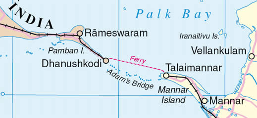
The most recent study of the Sethusamudram Shipping Canal Project, as it is now called, was an Environmental Impact Assessment and a Technical Feasibility Report commissioned by the Tamil Nadu government in 2004.

The strategic advantages to India derive from obtaining a navigable sea route close to the coast, with a reduction in travel distance of more than 350 nautical miles (650 km) (for larger ships). The project is expected to provide a boost to the economic and industrial development of coastal Tamil Nadu.

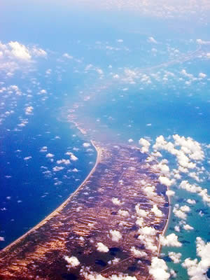
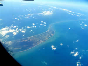
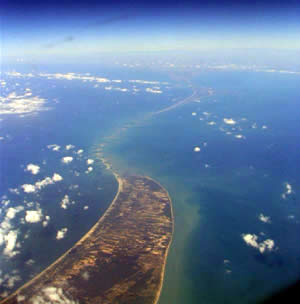
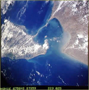
The Hindu epic Ramayana recounts how Lord Rama with the help of an army of Vanaras or monkeys built a bridge of stones across the sea to Lanka to rescue his wife Sita from the Asura king Ravana. The Ram Karmabhumi movement, encouraged by a NASA satellite photograph which they say proves that remnants of this bridge still exist, was formed to prevent the shipping canal from being built.